“Chur in 3D” is online!
The City of Chur has used PlexMap 3D to visualize its own “3D City Map” (featuring a 3D mesh and CityGML data) and has made it available online at 3dstadtplan.chur.ch. In addition to established content—such as the 3D mesh, terrain relief, and orthophotos—the application now also offers high-resolution oblique aerial imagery. For the first time, this enables a particularly realistic visualization of buildings and streetscapes. These image data layers can be overlaid with various other thematic datasets, such as city trees, zoning plans, municipal boundaries, or property lines.
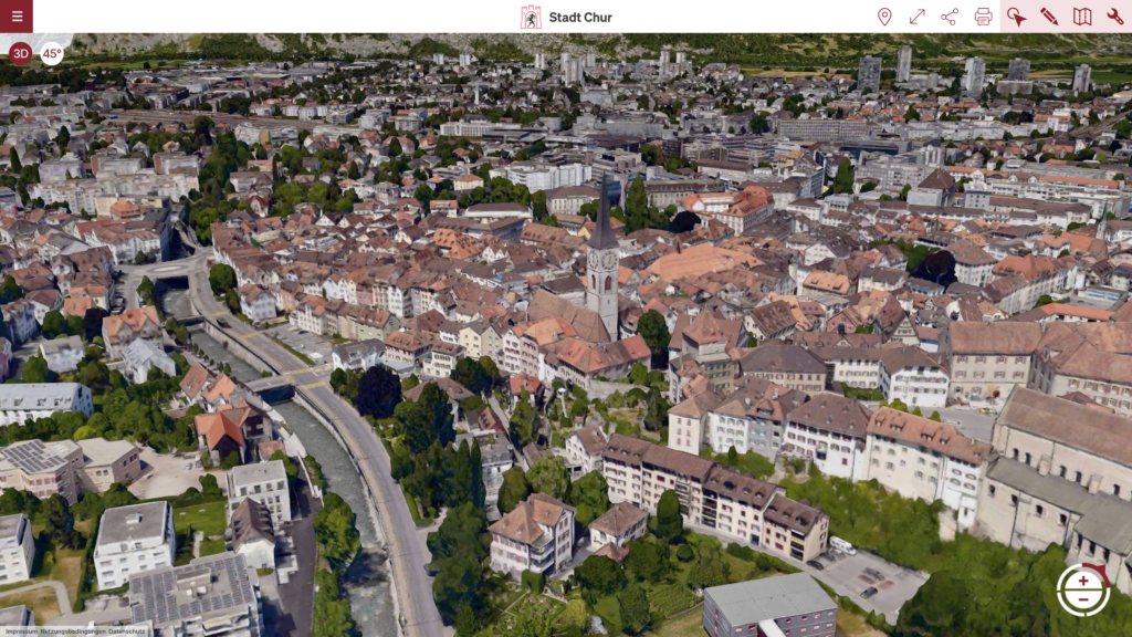
With the further development of its 3D city map, the City of Chur is strengthening its digital tools and providing the public with modern, easy access to a diverse range of valuable geodata sets. This summer, aerial flights will once again be conducted over the entire built-up area of the City of Chur, including the newly incorporated localities of Praden and Tschiertschen. The Geoinformatics Department plans to make the resulting aerial and oblique imagery publicly available on the new platform, likely in the autumn of 2026.
As part of the internal use of PlexMap 3D, particular focus was placed on the detailed modeling of the “Chur West” area. Within the framework of a joint project between the Rhaetian Railway (RhB) and the City, a new railway station is being constructed in Chur West, featuring an accessible, multimodal transport hub and public transport connections extending beyond Chur. In addition to traffic-specific and technical facilities, the station is being optimally designed to serve rail, bus, and PostBus services, as well as bicycle and pedestrian traffic, ensuring it can keep pace with the future growth of the Chur West district. Furthermore, an attractive station square featuring a shared-space zone is being created, along with a bicycle station with capacity for 170 bikes.